Published 13/7/2017 at 10 pm. Updated 19/7/2017 at 3:00 pm. Changes are marked with yellow background.
Preliminary competition guidelines 2017
KVARKEN ORIENTEERING FESTIVAL 20–22/7/2017
COMMON GUIDELINES FOR ALL THREE COMPETITIONS
(Additional instructions and course lengths for the respective competitions further down)
COMPETITION RULES: The rules of the Finnish Orienteering federation and the organisers’ guidelines.
COMPETITION MAP: Colour printout, July 2017. Scale 1:10 000,
on day 2 all classes use 1:7 500. In the classes D 60–75, H 60–85 as well as D and H 12, 12TR, 10RR and 8RR 1:7 500
every day. Contour interval 2,5 metres. The maps are displayed at the start each day. The competition maps are in plastic covers.
COMPETITION TERRAIN: Greetings from the course setters together with map examples and terrain pictures can be found
here.
CONTROLS: A model control can be found in the competition centre. There, do check that your Emit punching card works. If it doesn’t work, visit the Info to rent a working Emit card and change your Emit number in the start list.
COURSES: The course lengths and number of controls can be seen in the tables for respective competition below. The RR and TR courses are marked in the terrain and drawn on the maps.
PUNCHING: Electronic punching with the Emit system. Before the start, do check that your Emit card is working and that your Emit number is correct in the start list. You are not allowed to start with a faulty Emit number. Mistakes must be reported to the Info. Class and Emit changes: 2 euros. Emit cards can be rented from the Info at 5 euros per piece and must be returned after the competition. If an Emit card is not returned, 80 euros will be charged. If you participate on an open course, you are not allowed to use an Emit card that is used in a competition class.
MISPUNCHING: The controls must be visited in the correct order. A missing punch leads to disqualification, except for in the RR classes. There, each missing punch adds 10 minutes to the finish time.
GPS: In the classes D21A and H21A around 10 orienteers per day use GPS-transmittors. Check out the names on the results board and at www.kvarkentrio.fi and pick up your transmittor in the Info on time. Thank you – also for returning it at the finish. The GPS-orienteers and their results can be followed in the competition centres and on the web each day.
START NUMBERS: The classes D and H 16, 18, 20 and 21A use number vests every day. The vests can be picked up at the start. Return your vest at the finish.
START: Start lists with start times are presented two days before the events
here, on the result boards in the competition centre and at the starts. Follow the marking to your start:
- Start 1: D/H 16–21A. Blue tape.
- Start 2: D/H 35–85, 21B and 21C. White tape.
- Start 3: D/H 8RR, 10RR, 12TR, 12, 13 and 14 as well as Open RR. Yellow tape.
- Start 4: Open courses A and B. Orange tape.
You should be on site at the latest five (5) minutes before your starting time.
- At the start, you receive an Emit backup slip where you write down your Emit number.
- Control descriptions can be picked up at the start and are also printed on the map.
- Chasing start in the classes D and H21A, 20, 18 and 16 day 3. See the instructions for the final day.
THE START PROCEEDS AS FOLLOWS:
Classes D/H 16 – 80
4 minutes before the start: Roll call, proceed to the start entrance. Control descriptions available.
3 minutes before the start: Your Emit card will be cleared.
2 minutes before the start: Check out the model map.
1 minute before the start: Proceed to your map and wait for the start signal.
Start signal: Take the map. Your orienteering competition starts.
Classes D/H 8 – 14
4 minutes before the start: Roll call, proceed to the start entrance. Check out the model map:
- In the RR and TR classes, the courses are drawn on the model map.
- In the classes 12, 13 and 14, the start point is marked on the model map.
3 minutes before the start: Your Emit card will be cleared.
2 minutes before the start:- The RR participants receive their map and instructions.
- The TR participants may look at the model map, where the course is drawn.
- The participants in the classes 12, 13 and 14 may look at the model map where the start point is marked.
1 minute before the start:- The RR participants can study their map and course.
- The TR participants can take their map and study the course.
- The participants in the classes 12, 13 and 14 can take their map and study the course.
Startsignal: Your orienteering competition starts.
Open courses A, B and RR: Read more
here (Guidelines for the Open courses).
SIGNS: In the competition centre, there are signs and tapes that show the way to the start and other functions.
FORBIDDEN AREAS: All yards and fields (with black dots on) that are marked on the map are out-of-bounds areas, that you are not allowed to enter. Other possible out-of-bounds areas are specified separately for each competition.
FINISH: Follow the tape from the last control to the finish. All participants, also those who haven’t visited all controls, must punch at the finish line. If you miss the finish punch, you will be disqualified. When you have punched at the finish, you proceed to the punching check. After finishing, you can keep your map.
CONTROL RALLY: The Control rally (Rastiralli) is a course for everyone – especially the youngest ones – including funny tasks. You can start any time between 5:30 pm and 8 pm on Thursday and Friday and 10:30 am –1 pm on Saturday. Enter at the Control rally start, where you receive a Control rally passport. The entry fee is 3 euros. All participants will be rewarded.
PRIZES: All participants receive a prize when finishing. The best ones in each competition category after three events will also be rewarded. Check out the prizes on the website.
RESULTS: On the results board and online during the competitions:
kvarkentrio.fi/en/resultservice
ROUTE GADGET: Serves all participants: Remember to draw your routes
here and compare your results with the fellow-competitors.
CHILD-CARE (Muksula): For children in families that take part in the event. Let us know the name and age of your child and when you need help – at the latest Wednesday 19/7: Pia Lind (pia(at)enlund.fi / +358-50-3062345).
FIRST AID: Available in the competition centres.
O-SHOPS: Seppo Keltamäki and Suunnistajan Kauppa are at your assistance in the competition centres.
SERVICE: Next to the competition centres, you will find toilets and washing rooms in field conditions. As well: Welcome to our cafés!
GUIDELINES FOR EACH COMPETITION
Stage 1, Thursday 20/7 Kalapää, Vörå
ORGANISER: IF Femman
- Event director: Joakim Holmback
- Course setters: Pernilla Tunis, Berit Tunis
- Event advisor: Roy Torrkulla, IF Minken
GUIDANCE SIGNPOSTS from the south at the crossroads of E8 and road 725, in the north at the crossroads between E8 and road 718 and in the east at the crossroad 718 – 725. From Vörå centre: a 15 minutes drive.
PARKING: At a field next to the competition centre.
COMPETITION JURY:
FIRST START: 6 pm.
CLASSES, PRELIMINARY COURSE LENGTHS AND NUMBER OF CONTROLS| Start 1 | 600 metres, blue tape. |
| Class | Course length | Controls | Class | Course length | Controls |
| D21A | 4,3 km | 13 | H21A | 6,1 km | 17 |
| D20 | 3,7 | 10 | H20 | 4,8 | 15 |
| D18 | 3,4 | 12 | H18 | 4,1 | 13 |
| D16 | 3,0 | 10 | H16 | 3,4 | 12 |
| Start 2 | 600 metres, white tape. |
| Class | Course length | Controls | Class | Course length | Controls |
| D21B | 3,0 km | 10 | H21B | 4,1 km | 13 |
| | | H21C | 2,8 | 6 |
| D35 | 3,7 | 10 | H35 | 4,8 | 15 |
| D40 | 3,0 | 10 | H40 | 4,8 | 15 |
| D45 | 2,6 | 8 | H45 | 4,3 | 13 |
| D50 | 2,6 | 8 | H50 | 4,1 | 13 |
| D55 | 2,3 | 7 | H55 | 3,7 | 10 |
| D60 | 2,3 | 7 | H60 | 3,4 | 12 |
| D65 | 2,0 | 7 | H65 | 3,0 | 10 |
| D70 | 2,0 | 7 | H70 | 2,7 | 10 |
| D75 | 1,7 | 7 | H75 | 2,3 | 7 |
| | | H80 | 1,7 | 7 |
| | | H85 | 1,7 | 7 |
| Start 3 | 600 metres, yellow tape. (Open-RR: Enter at the Info) |
| Class | Course length | Controls | Class | Course length | Controls |
| D14 | 2,1 km | 6 | H14 | 2,1 km | 6 |
| D13 | 1,9 | 6 | H13 | 1,9 | 6 |
| D12 | 1,7 | 7 | H12 | 1,7 | 7 |
| D12TR | 1,3 | 5 | H12TR | 1,3 | 5 |
| D10RR | 2,0*/1,3 | 5 | H10RR | 2,0*/1,3 | 5 |
| D8RR | 2,0*/1,3 | 5 | H8RR | 2,0*/1,3 | 5 |
| Open-RR | 2,0*/1,3 | 5 | * = Length of the route tape |
| Start 4 | 600 metres, orange tape. Enter at the Info. |
| Class | Course length | Controls |
| Open A | 5,2 km | 15 |
| Open B | 3,1 | 9 |
COMPETITION CENTRE:
TERRAIN DISCRIPTION: The terrain consists mainly of several bigger hills divided by a few fields. The biggest elevation difference is around 20 metres. The terrain is quite fastpaced due to the many bedrock hills.
The bedrocks are mostly fast to run on, but there are some marsh vegetation areas on the bedrock hills that will slow down the pace. This vegetation are mapped as marsh and for your orienteering, better to be avoided. The courses cross the best parts of the terrain. Even if the terrain mostly consists of hills, there are clear paths for the youngest to follow. The map is drawn by Jussi Silvennoinen, also Jukola mapmaker this year.
Stage 2, Friday 21/7 Kolnebacken, Malax
ORGANISER: Malax IF
- Event director: Richard Strandberg
- Course setter: Tommy Holmback
- Event advisor: Karl Gustav Norrgrann, Närpes OK
GUIDANCE SIGNPOSTS from road E8, 31 km south of Vasa (the Jurva crossing). A five minutes drive.
PARKING: Along roads. Walk to the competition centre: 100 m – 1,5 km.
COMPETITION JURY:
FIRST START: 6 pm.
MAP: NOTE! Scale 1:7 500 in all classes!
CLASSES, PRELIMINARY COURSE LENGTHS AND NUMBER OF CONTROLS| Start 1 | 300 metres, blue tape. |
| Class | Course length | Controls | Class | Course length | Controls |
| D21A | 4,5 km | 19 | H21A | 5,6 km | 26 |
| D20 | 4,0 | 19 | H20 | 5,1 | 24 |
| D18 | 3,4 | 13 | H18 | 4,6 | 19 |
| D16 | 2,7 | 13 | H16 | 3,4 | 13 |
| Start 2 | 300 metres, white tape. |
| Class | Course length | Controls | Class | Course length | Controls |
| D21B | 2,3 km | 10 | H21B | 4,5 km | 19 |
| | | H21C | 2,6 | 11 |
| D35 | 4,0 | 19 | H35 | 5,1 | 24 |
| D40 | 3,4 | 13 | H40 | 4,5 | 19 |
| D45 | 3,4 | 13 | H45 | 4,5 | 19 |
| D50 | 2,7 | 13 | H50 | 4,6 | 19 |
| D55 | 2,7 | 13 | H55 | 4,0 | 19 |
| D60 | 2,5 | 10 | H60 | 3,4 | 13 |
| D65 | 2,5 | 10 | H65 | 3,4 | 13 |
| D70 | 2,4 | 10 | H70 | 2,7 | 13 |
| D75 | 2,4 | 10 | H75 | 2,5 | 10 |
| | | H80 | 2,4 | 10 |
| | | H85 | 2,4 | 10 |
| Start 3 | 300 metres, yellow tape. (Open-RR: Enter at the Info) |
| Class | Course length | Controls | Class | Course length | Controls |
| D14 | 2,6 km | 11 | H14 | 2,6 km | 11 |
| D13 | 2,3 | 10 | H13 | 2,3 | 10 |
| D12 | 2,0 | 10 | H12 | 2,0 | 10 |
| D12TR | 1,6 | 8 | H12TR | 1,6 | 8 |
| D10RR | 1,7* | 6 | H10RR | 1,7* | 6 |
| D8RR | 1,7* | 6 | H8RR | 1,7* | 6 |
| Open-RR | 1,7* | 6 | * = Length of the route tape |
| Start 4 | 100 metres, orange tape. Enter at the Info. |
| Class | Course length | Controls |
| Open A | 4,8 km | 19 |
| Open B | 3,2 | 14 |
COMPETITION CENTRE:
 TERRAIN DESCRIPTION:
 The treasures of Kolnebacken, serving Malax with gravel and water for a long time, now open up for us orienteers! Here, your orienteering capacity will be put to a real test, sometimes feeling very easy – at the next moment really difficult. The runnability is mostly good, but the green areas on the map are naturally slower. Key words are precision and the ability to change tempo. As well, there are lots of controls in the terrain:
check the code!
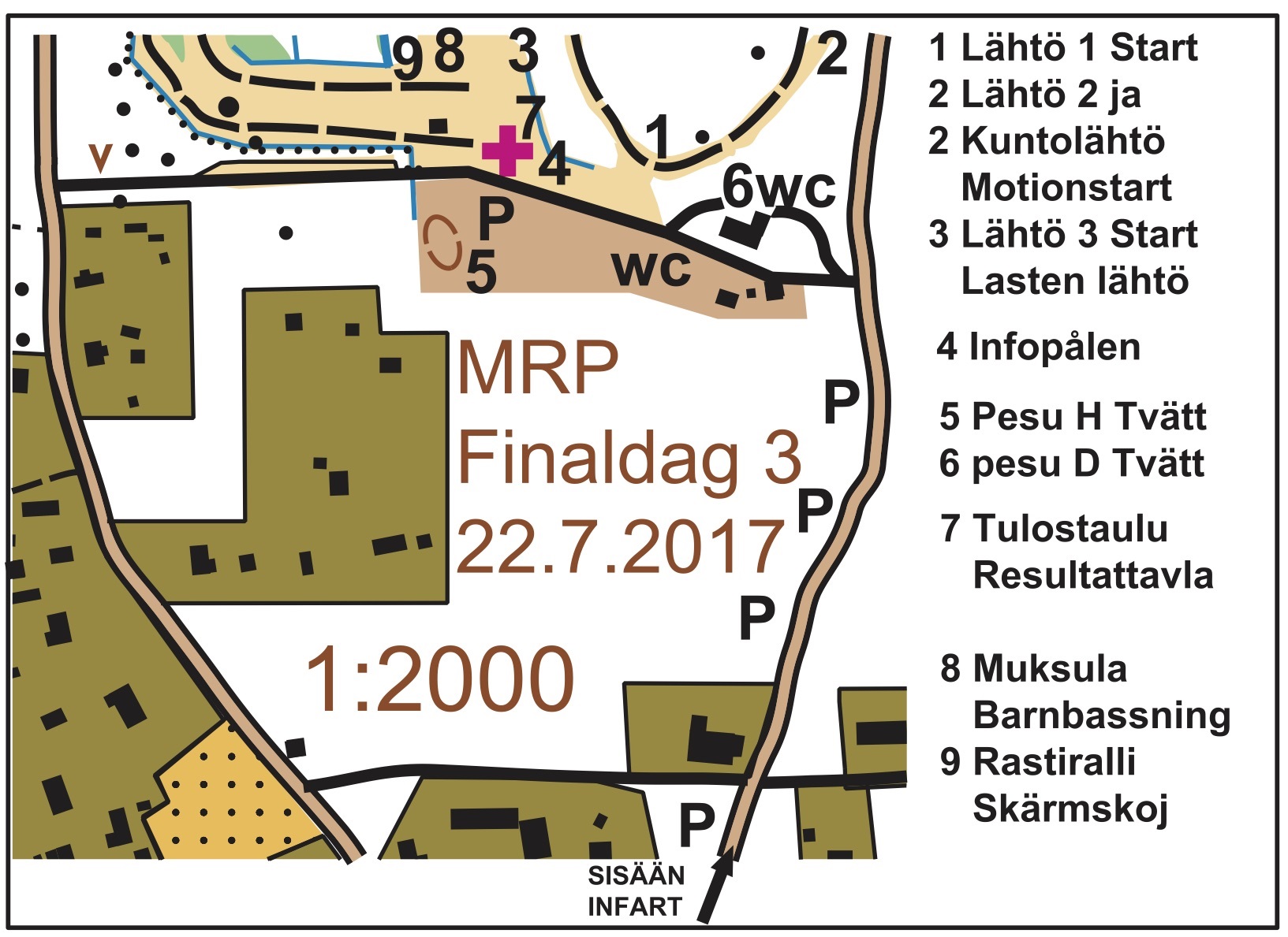
Stage 3, Saturday 22/7 Saarenpää, Vähäkyrö
ORGANISER: Vaasan Suunnistajat
- Event director: Pertti Välimaa
- Course setters: Kalevi Mäki-Maunus and Eveliina Välimaa
- Event advisor: Heikki Tamminen, Suunta-Jurva
GUIDANCE SIGNPOSTS from central Vähäkyrö, road 717 and Jokivarsitie.
PARKING: On the field next to the competition centre. Along the road with a 50 – 650 metres walk to the competition centre.
COMPETITION JURY:
FIRST START: 11 am. Chasing start in the classes D/H21A, 20, 18 and 16. Those who are more than 30 minutes behind the leader or do not have an overall result will start at the end of the field, with interval start.
CLASSES, PRELIMINARY COURSE LENGTHS AND NUMBER OF CONTROLS| Start 1 | In the competition centre, blue tape. |
| Class | Course length | Controls | Class | Course length | Controls |
| D21A | 5,1 km | 12 | H21A | 6,9 km | 18 |
| D20 | 4,0 | 11 | H20 | 4,6 | 11 |
| D18 | 3,4 | 11 | H18 | 3,8 | 12 |
| D16 | 3,0 | 10 | H16 | 3,3 | 11 |
| Start 2 | 350 metres, white tape. |
| Class | Course length | Controls | Class | Course length | Controls |
| D21B | 2,4 km | 10 | H21B | 4,5 km | 11 |
| | | H21C | 2,4 | 10 |
| D35 | 3,8 | 11 | H35 | 5,1 | 12 |
| D40 | 3,2 | 11 | H40 | 4,9 | 11 |
| D45 | 3,2 | 11 | H45 | 4,5 | 11 |
| D50 | 2,5 | 9 | H50 | 4,1 | 11 |
| D55 | 2,5 | 9 | H55 | 3,8 | 11 |
| D60 | 2,5 | 8 | H60 | 3,5 | 10 |
| D65 | 2,2 | 8 | H65 | 3,2 | 9 |
| D70 | 2,0 | 7 | H70 | 2,5 | 8 |
| D75 | 1,7 | 7 | H75 | 2,2 | 8 |
| | | H80 | 2,0 | 7 |
| | | H85 | 1,7 | 7 |
| Start 3 | 180 metres, yellow tape. (Open-RR: Enter at the Info) |
| Class | Course length | Controls | Class | Course length | Controls |
| D14 | 2,2 km | 7 | H14 | 2,4 km | 7 |
| D13 | 1,9 | 8 | H13 | 1,9 | 8 |
| D12 | 1,5 | 7 | H12 | 1,5 | 7 |
| D12TR | 1,5 | 6 | H12TR | 1,5 | 6 |
| D10RR | 1,9*/1,4 | 6 | H10RR | 1,9*/1,4 | 6 |
| D8RR | 1,9*/1,4 | 6 | H8RR | 1,9*/1,4 | 6 |
| Open-RR | 1,9*/1,4 | 6 | * = Length of the route tape |
| Start 4 | 350 metres, orange tape. Enter at the Info. |
| Class | Course length
| Controls |
| Open A | 4,8 km | 13 |
| Open B | 3,0 | 11 |
COMPETITION CENTRE:
 FINISH:
 In the classes D/H 16 – 21A the final positions will be decided at the finish line, not by the finish punch. If needed, the finish judge will determine the final order.
TERRAIN DISCRIPTION: The competition terrain varies a lot. Broken hills with bedrocks and cliffs make the orienteering difficult. On the other hand, the hills and knolls are clearly visible in the terrain. Ditches with green borders slow down the pace. Fields of boulders appearing in the terrain do not disturb the orienteering!
Merry orienteering days!
IF Femman, Malax IF & Vaasan Suunnistajat]]>
 FINISH: In the classes D/H 16 – 21A the final positions will be decided at the finish line, not by the finish punch. If needed, the finish judge will determine the final order.
TERRAIN DISCRIPTION: The competition terrain varies a lot. Broken hills with bedrocks and cliffs make the orienteering difficult. On the other hand, the hills and knolls are clearly visible in the terrain. Ditches with green borders slow down the pace. Fields of boulders appearing in the terrain do not disturb the orienteering!
FINISH: In the classes D/H 16 – 21A the final positions will be decided at the finish line, not by the finish punch. If needed, the finish judge will determine the final order.
TERRAIN DISCRIPTION: The competition terrain varies a lot. Broken hills with bedrocks and cliffs make the orienteering difficult. On the other hand, the hills and knolls are clearly visible in the terrain. Ditches with green borders slow down the pace. Fields of boulders appearing in the terrain do not disturb the orienteering!